I did say that there would not be any more posts but here are the videos that I put together to show my experience at the 2011 Etape Du Tour Acte 1.
Enjoy in HD by clicking the 320p icon and changing it to 1080p.
Enjoy.
http://youtu.be/8xsTYzF9oYA
http://youtu.be/6KulK_udm9A
http://youtu.be/AK6cbNO2ejk
Alpe D'Huez

Training in the Lakes

Pain on Newlands Pass
Friday, 19 August 2011
Wednesday, 10 August 2011
And So ......The End
This will be the final post that I write because, well, the journey is over.
I have just sent all the remaining money to Parkinson's UK and The Alzheimers Society and for the record I have raised over £1000 for the former and over £1100 for the latter.
All that remains now is to fill you in on the last three days of the our trip to France.
After the Etape was over and we left the Alpe D'Huez, we headed back over the route in the car so that Amanda could see where I had been, stopping what seemed, every few miles to take photos and video footage.
Our destination was a small Chateau on the outskirts of Chambery, which we hoped would be something of a treat.
We arrived to sauna-like heat and were given a room in the annex with no air conditioning, which we had specifically booked. Amandas blood was boiling since she had complained and got a "it's not our problem" sort of comment from the lady on reception. She instructed me to get on the Internet straight away so she could check the booking (one of those moments to do exactly as you are told) and before we knew it we had been moved into a fully air conditioned room. This is despite the fact that Amanda can only speak roughly three sentences in French and one of those is to ask for an ice cream :-) Good job though, it was boiling that night.
Once settled, I cleaned the bikes behind one of the buildings using shower gel from the room (I thought they might object and I forgot my own cleaning liquid). This gel was really posh stuff as well. As I washed down Lord Trekington (my bike) I could almost sense him making the kind of orgasmic sounds that the girls in those adverts do.
We had always wanted to see Lake Annecy, so I set about plotting the most direct route possible, with Amanda looking increasingly worried as she saw the profile. After much debate, I had cracked it. around 71 miles and a couple of decent climbs to keep me happy.
The following morning though it was grey..... we got all our stuff together and put our waterproofs on from the off, although it was not raining at this stage.
Not long after we left the hotel though we started up the Col De Plainpalais which was over 16km in length. Then as we exited a tunnel, the rain started.... torrential and cold. But we were ready for it and we knew how lovely Lake Annecy was.
 The rain was getting worse though and was steadily soaking us to the skin. We were fortunate, I suppose that we plotted the route to be harder on the way out. Not least because as the day wore on, Amanda was too tired to catch me up and strangle me..... You see the route was a good deal longer because of the numerous hairpin bends... in fact 82 miles in total. And it rained, boy did it rain.
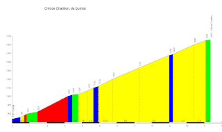
We finished this climb and not too long after, were on another, the Cret de Chatillon, which takes you up towards the ski resort of La Semnoz, which I found out later, has been used in the Tour De France.
This climb is shorter but much steeper and the incessant rain would not give up as the beautiful scenery unfolded all around us.
 It was getting colder though and as we got towards the top, the wind picked up and the sheltering trees disappeared to reveal the "Plateau" restaurant - it was shut - sob, but Amanda got behind my wheel and battled her way to the top.
 Amanda was beginning to smile as we made good progress and the better weather continued - this was of course to be short lived. As the extent of the extra mileage became evident, so to did the final climb of the day, the Col Des Pres (pass of the meadows), and it was as lovely as it sounds. But Amanda had, had enough and was giving me the death stare.
I have just sent all the remaining money to Parkinson's UK and The Alzheimers Society and for the record I have raised over £1000 for the former and over £1100 for the latter.
All that remains now is to fill you in on the last three days of the our trip to France.
After the Etape was over and we left the Alpe D'Huez, we headed back over the route in the car so that Amanda could see where I had been, stopping what seemed, every few miles to take photos and video footage.
Our destination was a small Chateau on the outskirts of Chambery, which we hoped would be something of a treat.
We arrived to sauna-like heat and were given a room in the annex with no air conditioning, which we had specifically booked. Amandas blood was boiling since she had complained and got a "it's not our problem" sort of comment from the lady on reception. She instructed me to get on the Internet straight away so she could check the booking (one of those moments to do exactly as you are told) and before we knew it we had been moved into a fully air conditioned room. This is despite the fact that Amanda can only speak roughly three sentences in French and one of those is to ask for an ice cream :-) Good job though, it was boiling that night.
Once settled, I cleaned the bikes behind one of the buildings using shower gel from the room (I thought they might object and I forgot my own cleaning liquid). This gel was really posh stuff as well. As I washed down Lord Trekington (my bike) I could almost sense him making the kind of orgasmic sounds that the girls in those adverts do.
We had always wanted to see Lake Annecy, so I set about plotting the most direct route possible, with Amanda looking increasingly worried as she saw the profile. After much debate, I had cracked it. around 71 miles and a couple of decent climbs to keep me happy.
The following morning though it was grey..... we got all our stuff together and put our waterproofs on from the off, although it was not raining at this stage.
Not long after we left the hotel though we started up the Col De Plainpalais which was over 16km in length. Then as we exited a tunnel, the rain started.... torrential and cold. But we were ready for it and we knew how lovely Lake Annecy was.

We finished this climb and not too long after, were on another, the Cret de Chatillon, which takes you up towards the ski resort of La Semnoz, which I found out later, has been used in the Tour De France.
This climb is shorter but much steeper and the incessant rain would not give up as the beautiful scenery unfolded all around us.
 It was getting colder though and as we got towards the top, the wind picked up and the sheltering trees disappeared to reveal the "Plateau" restaurant - it was shut - sob, but Amanda got behind my wheel and battled her way to the top.
A 17.4km descent into Annecy was next, in rain so strong that it was a struggle to see. With fingers constantly on the brakes to prevent our speed getting out of control, both our hands and fingers were going numb, and we were having to wring our hands to get the feeling back.
We arrived in Annecy and eventually found a cafe. We were frozen and the only place that we could find only had an outdoor covered section.
Amanda was shivering as she ordered two coffee which were tiny ( oh for a mug). We ended up having four and they still didn't warm us up, and neither did omlette and chips.
We were actually looking forward to getting back on the bike to get warm again when we had a blessing in disguise, a puncture. Ordinally we would use our little compressor to re-inflate the tyre but hand pumping with a mini pump was just what the doctor ordered.
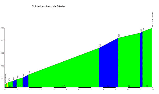
We turned away from Lake Annecy as the rain stopped and the sun came out! and began the long but shallow climb of the Col de Leschaux
 Amanda was beginning to smile as we made good progress and the better weather continued - this was of course to be short lived. As the extent of the extra mileage became evident, so to did the final climb of the day, the Col Des Pres (pass of the meadows), and it was as lovely as it sounds. But Amanda had, had enough and was giving me the death stare.
We got to the top and were greeted by more black clouds in the distance, so it was back on with the jackets and another freezing cold descent back to the hotel.
We showered, changed and laid all the kit out in the room to dry before heading off to Carrefore for comfort food.
The Col Des Saises
One of the things that caught my eye was when watching the 2009 edition of the Tour De France. Stage 17 involved a climb called the Col Des Saises, and when the peleton descended into the town of Flumet, there was a fantastic helicopter shot of an amazingly curly road with all the rides going down it.... here is the video.
We had both seen this and I was desperate to do this descent.
Without going into too much detail, the climb was long but not too severe and although there was enough low cloud to prevent us seeing Mont Blanc, the rain held off.
The run down is fantastic and I would recommend it to anyone, especially as rather than turn right as the Tour did, we went left and headed down the valley along side the river, the road cut into the rock and there were more bridges and tunnels than you could shake a mini-pump at.
A small climb back over the Col De La Forclaz and we were back at the car and heading back for our final evening.
It should have been something special really but it was Bastille day and most of France was shut down. Carrefore it was then. More comfort food and a couple of cans of 8.5% beer - slept well that night.
Thanks for reading THE END
Friday, 22 July 2011
France - July 2011 - The Etape Du Tour
Now that we are home again it has taken me a little bit of time to get the creative juices flowing, so I hope that I can convey my thoughts well enough to keep you reading.
The trip started on Thursday 7th July when I pretty much went straight from work to catch the ferry at Portsmouth - Amanda had booked the day off and that, coupled with a great deal of work the night before, everything was packed and we flung ourselves head-long in to the chaos that was getting onto the ferry (wait in a queue for a bit, move forward to another queue....... add as many steps as you want to here). Still, Portsmouth is not the most quaint of places and it serves as a really good place to get out of the country (it's all you want to do once you get there).
Once though, we found our cabin, dropped the overnight stuff and headed for the onboard delights of the "Dirty Duck", "Pub" and began on the pint that I hoped would get me nicely off to sleep. There was just enough time to "tweet", my where-abouts to the people that mean the most to me (it turned out to be an excellent way of keeping people up-to-date).
Friday morning duly arrived and we pulled into Le Havre, which I was amazed to learn is now a UNESCO World Heritage site, and we faced up to the enormity of the drive to the outskirts of Grenoble - some 37 light years away by car.
I won't dwell on this part of the trip other than to say that 1. French roads are awesome, 2. I love the little picnic areas that area regularly dotted along these routes, 3. French drivers scare the pants off you at first - if people drove so close in England nobody would get anywhere as they would stopping to have a "road-rage" related fight every few miles.
We arrived in Saint-Egreve, just North of Grenoble at around 6pm, without too much fuss thanks to the Sat Nav, unloaded the car and set about the fruitless task of finding somewhere to eat, ending up back at the hotel resturant after a mile of walking in the evening heat.
Our short term reality show "A Salesman's Life" continued promptly the next morning as we reloaded the car and headed off to our first main base of Saint Jean De Maurienne (where joy-of-joys) we would actually be spending two nights. On the way we passed through Le Bourg d'Oisans, and took the opportunity to drive up Alpe D'Huez, firstly to have a look at it and secondly to find the hotel that we would be staying in after the Etape.
Back on the road and a dramatic drive over the Col De La Croix De Fer took us to the hotel in SJDM. A modest affair but the room was big enough to fit the bike in and was high enough up to see the mountains over the town.
We decided to go for a short bike ride to stretch the legs and a short trip up the first couple of Km of the CDLCDF and back down was enough during the heat which, shortly after we got back, gave way to an enormous thunderstorm, clearing the air nicely.
Sunday meant that we had to go and register so we hitched a bus journey to the tented village high above the start town of Modane. An hour was spent taking care of the formalities and then gaining every single freebie that we could.
The bus arrived back at the hotel early enough for us to go for a short ride so we joined up with Martin and Sarah from our hotel and set off up the Col Du Mollard which was straight out from the back of the hotel but which turned out to be a ten and a half mile Category 1 climb.
Sarah and Martin chose to save their energy and turned back about halfway up but myself and Amanda completed the climb and then headed back for our pre-ride meal.
4am was the alarm call and having organised all my gear the night before I was feeling quite calm and went down for breakfast in shorts and a tee shirt, quietly chuckling to myself at all the others who came down in their full cycling kit - so uncomfy (a lesson learned from "Fat Camp").
30 minutes later and I was changed and on the bus ready to go. I bid farewell to Amanda who to set off for the finish as soon as I left and the bus started on the long-ish drive to the start.

We had a group of "all the gear and no idea" Americans on the bus with us and they were complaining that we were being dropped of too far from the start and that they wanted to be taken closer to Modane ( in hindsight an extremely wise move as the road was much longer and more uphill than it first appeared).
As we progressed we overtook a steady stream of cyclists before hitting solid traffic, and only because we were bigger than most, our driver forced his way through in to a car park and we got off, gathered out strength and headed the final 5km towards Modane.
The Etape Du Tour 2011 Acte 1
According to everyone that I spoke to I had quite a low "dossard" (start number) and this put me reasonably close to the front in terms of starting.
A man (who turned out to be a woman) constanly relayed information in several different languages over the tannoy system - yep, nobody had a "lie-in" in Modane that morning.
Finally the Mayor of Modane gave the word and my group were off at around 7.40am and it was chilly to say the least as the sun hid behind the Alpine landscape.
The route started with a really fast 20 Km downhill run to Saint Michel De Maurienne and then came the left turn to signify the start of the action - the Col Du Telegrape - which is right above your head as you make this turn, leaving you wondering how are we going to get that high in such a short relative distance. The answer is easy - loads of hairpin bends, a trip round a gorge to the tune of 11.8km and an average gradient of 7.3%.
I had made my mind up to ride this climb very steadily, trying not to let my heart rate get above 150, which I pretty much managed.
This climb was a joy in the early morning light with the sun just beginning to take away the early chill, but it just keeps going - snaking up the early sections and then hugging the left side of a ravine before sweeping around the back of this chasm to arrive at the summit on the far side. The last section of which can be seen as you glance to your right and up..... a familiar glance as the day went on.
There were quite a few people at the summit of the Telegraphe, but I chose not to stop at the feed station there, as even at my steady pace I was feeling quite strong and had passed more than few riders on the way up.
So I continued down the 5km decent that took you to the beautiful alpine town of Valloire and the base of the Col Du Galibier.
I did not really have too much time to take in much about the town but noticed a series of wooden carvings on the traffic roundabout, and a fellow dressed in a cow suit, who I duly "high fived" as I went past. This all helped to take my mind of the fact that the gradient had started to rise considerably in the blink of an eye.
Shortly after I exited the town I stopped at the village-sized feed station and refilled my water bottles, but conscious of not letting my legs stiffen up too much, got straight back on the bike and headed off - destination - the top of the world.
The Galibier is truly beautiful .... gone were the trees and gorges, replaced by snow capped peaks and Alpine meadows, abundant with scores of butterflies and bees.
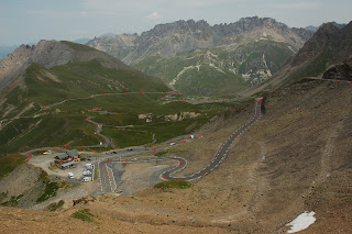
As the road climbs past a couple of hairpin bends it heads onwards through a gap between peaks to a place called Plan Lachet where the road turns hard right, over a bridge and back on itself - and here's where the fun really starts?!!?
 You can see this whole section from a fair distance away but what you don't realise at first is that this is the first in a series of hairpin bends that take you up to the next plateau. It's only when you see all the riders ahead and trace them up the hill that the enormity unfolds. This whole section is much steeper and like the other climbs that we undertook in the Alps, is very consistant with not much chance to rest.
 Plan Lachet is just out of shot in the botom right hand of this photo but this gives you an idea of of the sheer scale of this section and what a visual impact it can have on you as a rider. You can click on this photo to see it in full size and Valloire is just visible in the distance.
When you have got to the top of this section the road sweeps away to the right, then swings away to the left and over a bridge (from where I took this photo the following day), and then back round to the right past the brand new monument to the late, great Marco Pantani.
 Another left turn and you can see the summit by tracing the riders up! It's high but only looks about 2km away (you appear on this photo where the first red dot is just to right of centre).
At almost the same moment you past the 5km to go stone (each Alpine climb has a stone every km to indicate how far is left and what the average gradient is for the next km, similar to the one below). A kick in the teeth for sure, and not the last.
 The road swings again to the left and steadliy climbs towards the final two km which are the steepest of the whole climb, hovering between 9% and 11% which is brutal after having been climbing for that long.
With one km to go you pass the tunnel which is used when the summit is closed and enter the final section of hairpins on freshly laid, super-smooth tarmac.
Still climbing steadily I was recovering from an error in judgement. I wasn't really aware of the effects of the altitude, until, with my mouth feeling dry I took a big gulp from my water bottle, missing a breath cycle in the process. It must have took me 15 breaths to "get my breath back" and for a while I was gasping for air.
From then on it was sips only.
At the same time a British couple were setting up their camper van in readiness for the Tour de France, which would come by a full 11 days later. Now that's dedication.
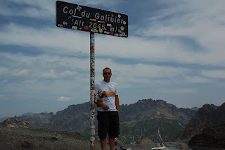
The summit finally arrived and because there was so many people around I almost missed it and didn't see the summit marker at all.
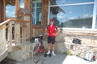
A good reason to go back the following day and join the queue for the obligatory photo by the alitiude sign.
 (My dog insisted on coming)
It was surprisingly warm going over the top of the Galibier - no need for the arm warmers or windproof jacket that I was carrying. But it was not too warm at this stage especially as the first part of the descent is 12 % and on a freshly resurfaced road, that was littered with hairpin bends and blind corners.
 This sign signifies the start of around 40km of decending, which is an experience like nothing I have encountered before. With closed roads and the abilty to therefore use the whole road, being able to see where you were going for a long distance and speeds averaging around 45mph for almost three quarters of an hour, I likened it to spending a whole day at Alton Towers without ever getting off a ride.
One of the greatest thrills of my life.
 The Henri Desgranges Memorial.
 The Glacier De La Meije
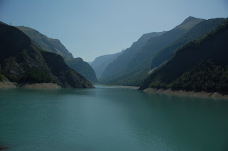 ....which is one of the many "man-made" lakes the French have created to harness Hydro-electric power. You sometimes wonder if these pictures have been "doctored" due to the colour of the water - being so aqua-blue. Well having taken this picture myself I can assure you that it really is that colour! This picture is taken from the dam that marks the end of the main lake which we would all pass over in a while.
 You could sense the nervousness amoungst all the people that I was around on this stretch, certainly nobody was really pushing the pace and I sat behind a French Gentleman who looked a good few years my senior as he munched on a sandwich and chucked the foil into the undergrowth - AAARRRRRGGGGHHHH!! My pet hate - still I had all my litter in my back pockets so I was able to take my own silent "moral high ground". Blooming unecessary though, and in such beautiful surroundings too, etc, etc - Alright Alex, I think we have got the message.
 Still there is no let up in the gradient. I rounded a corner to see a camper van with a Union Jack draped over it and shouted (not very loudly), "Come on you Brits", to which I received a huge cheer from the occupants - lovely, it really does keep you going. My unrelenting slow pace continued past Huez village and finally the pitch of the road backed off a little, and it was at this point I could see a Dutch camper van parked up and the family, pouring cold water down the necks of passing riders. I got both the two girls and the Dad to cool me down, which felt fantastic, and I reserved my best "Merci" of the week for them. Why you may ask, the were Dutch - well I worked on the idea that their French was a good deal better than my Dutch.
The beatuful Amanda was waiting for me at bend number 1 just before the "Flamme Rouge" (meaning red kite) and is above the road at the one km to go mark. She didn't see me coming until the last moment and almost missed me.
Once past the 1 km mark the road flattens a bit for the first time and goes past numerous bars and eateries - I don't think many of the riders will appreciate the guys cheering here while taking sips of their ice cold beers, but still the thought was there.
Past our future hotel and maybe 500 metres of downhill - then the final left hand turn, and you've guessed it, a final uphill section to the line. I can remember seeing this and turning to the guy at the side of me and saying "Oh for crying out loud".
I crossed the line in a blaze of sweat and jelly legs while "You can leave your hat on", by Tom Jones (from the Full Monty) played over the loud speakers. There were hundreds of people around the finish and I have to honest and the ladies were going mad at this music, I decided not to perform a striptease at this time as I thought they would be most disappointed.
I recorded a short message just after I finished as Amanda could not get there in time so I don't have an actual shots of me crossing the line - I do have it on video so I will post that as soon as I can.
And that's it really. I got my medal and goody bag and freewheeled back to the hotel, where Amanda meet me with an ice cold Coke - bliss.
 I will detail the remainer of the trip in a fresh post but before I finish there are a few people that I would like to say a massive thank you to.......
The trip started on Thursday 7th July when I pretty much went straight from work to catch the ferry at Portsmouth - Amanda had booked the day off and that, coupled with a great deal of work the night before, everything was packed and we flung ourselves head-long in to the chaos that was getting onto the ferry (wait in a queue for a bit, move forward to another queue....... add as many steps as you want to here). Still, Portsmouth is not the most quaint of places and it serves as a really good place to get out of the country (it's all you want to do once you get there).
Once though, we found our cabin, dropped the overnight stuff and headed for the onboard delights of the "Dirty Duck", "Pub" and began on the pint that I hoped would get me nicely off to sleep. There was just enough time to "tweet", my where-abouts to the people that mean the most to me (it turned out to be an excellent way of keeping people up-to-date).
Friday morning duly arrived and we pulled into Le Havre, which I was amazed to learn is now a UNESCO World Heritage site, and we faced up to the enormity of the drive to the outskirts of Grenoble - some 37 light years away by car.
I won't dwell on this part of the trip other than to say that 1. French roads are awesome, 2. I love the little picnic areas that area regularly dotted along these routes, 3. French drivers scare the pants off you at first - if people drove so close in England nobody would get anywhere as they would stopping to have a "road-rage" related fight every few miles.
We arrived in Saint-Egreve, just North of Grenoble at around 6pm, without too much fuss thanks to the Sat Nav, unloaded the car and set about the fruitless task of finding somewhere to eat, ending up back at the hotel resturant after a mile of walking in the evening heat.
Our short term reality show "A Salesman's Life" continued promptly the next morning as we reloaded the car and headed off to our first main base of Saint Jean De Maurienne (where joy-of-joys) we would actually be spending two nights. On the way we passed through Le Bourg d'Oisans, and took the opportunity to drive up Alpe D'Huez, firstly to have a look at it and secondly to find the hotel that we would be staying in after the Etape.
Back on the road and a dramatic drive over the Col De La Croix De Fer took us to the hotel in SJDM. A modest affair but the room was big enough to fit the bike in and was high enough up to see the mountains over the town.
We decided to go for a short bike ride to stretch the legs and a short trip up the first couple of Km of the CDLCDF and back down was enough during the heat which, shortly after we got back, gave way to an enormous thunderstorm, clearing the air nicely.
Sunday meant that we had to go and register so we hitched a bus journey to the tented village high above the start town of Modane. An hour was spent taking care of the formalities and then gaining every single freebie that we could.
The bus arrived back at the hotel early enough for us to go for a short ride so we joined up with Martin and Sarah from our hotel and set off up the Col Du Mollard which was straight out from the back of the hotel but which turned out to be a ten and a half mile Category 1 climb.
Sarah and Martin chose to save their energy and turned back about halfway up but myself and Amanda completed the climb and then headed back for our pre-ride meal.
4am was the alarm call and having organised all my gear the night before I was feeling quite calm and went down for breakfast in shorts and a tee shirt, quietly chuckling to myself at all the others who came down in their full cycling kit - so uncomfy (a lesson learned from "Fat Camp").
30 minutes later and I was changed and on the bus ready to go. I bid farewell to Amanda who to set off for the finish as soon as I left and the bus started on the long-ish drive to the start.

We had a group of "all the gear and no idea" Americans on the bus with us and they were complaining that we were being dropped of too far from the start and that they wanted to be taken closer to Modane ( in hindsight an extremely wise move as the road was much longer and more uphill than it first appeared).
As we progressed we overtook a steady stream of cyclists before hitting solid traffic, and only because we were bigger than most, our driver forced his way through in to a car park and we got off, gathered out strength and headed the final 5km towards Modane.
The Etape Du Tour 2011 Acte 1
According to everyone that I spoke to I had quite a low "dossard" (start number) and this put me reasonably close to the front in terms of starting.
A man (who turned out to be a woman) constanly relayed information in several different languages over the tannoy system - yep, nobody had a "lie-in" in Modane that morning.
Finally the Mayor of Modane gave the word and my group were off at around 7.40am and it was chilly to say the least as the sun hid behind the Alpine landscape.
The route started with a really fast 20 Km downhill run to Saint Michel De Maurienne and then came the left turn to signify the start of the action - the Col Du Telegrape - which is right above your head as you make this turn, leaving you wondering how are we going to get that high in such a short relative distance. The answer is easy - loads of hairpin bends, a trip round a gorge to the tune of 11.8km and an average gradient of 7.3%.
I had made my mind up to ride this climb very steadily, trying not to let my heart rate get above 150, which I pretty much managed.
This climb was a joy in the early morning light with the sun just beginning to take away the early chill, but it just keeps going - snaking up the early sections and then hugging the left side of a ravine before sweeping around the back of this chasm to arrive at the summit on the far side. The last section of which can be seen as you glance to your right and up..... a familiar glance as the day went on.
There were quite a few people at the summit of the Telegraphe, but I chose not to stop at the feed station there, as even at my steady pace I was feeling quite strong and had passed more than few riders on the way up.
So I continued down the 5km decent that took you to the beautiful alpine town of Valloire and the base of the Col Du Galibier.
I did not really have too much time to take in much about the town but noticed a series of wooden carvings on the traffic roundabout, and a fellow dressed in a cow suit, who I duly "high fived" as I went past. This all helped to take my mind of the fact that the gradient had started to rise considerably in the blink of an eye.
Shortly after I exited the town I stopped at the village-sized feed station and refilled my water bottles, but conscious of not letting my legs stiffen up too much, got straight back on the bike and headed off - destination - the top of the world.
The Galibier is truly beautiful .... gone were the trees and gorges, replaced by snow capped peaks and Alpine meadows, abundant with scores of butterflies and bees.
As the road climbs past a couple of hairpin bends it heads onwards through a gap between peaks to a place called Plan Lachet where the road turns hard right, over a bridge and back on itself - and here's where the fun really starts?!!?

 Plan Lachet is just out of shot in the botom right hand of this photo but this gives you an idea of of the sheer scale of this section and what a visual impact it can have on you as a rider. You can click on this photo to see it in full size and Valloire is just visible in the distance.
When you have got to the top of this section the road sweeps away to the right, then swings away to the left and over a bridge (from where I took this photo the following day), and then back round to the right past the brand new monument to the late, great Marco Pantani.

At almost the same moment you past the 5km to go stone (each Alpine climb has a stone every km to indicate how far is left and what the average gradient is for the next km, similar to the one below). A kick in the teeth for sure, and not the last.
The road swings again to the left and steadliy climbs towards the final two km which are the steepest of the whole climb, hovering between 9% and 11% which is brutal after having been climbing for that long.With one km to go you pass the tunnel which is used when the summit is closed and enter the final section of hairpins on freshly laid, super-smooth tarmac.
Still climbing steadily I was recovering from an error in judgement. I wasn't really aware of the effects of the altitude, until, with my mouth feeling dry I took a big gulp from my water bottle, missing a breath cycle in the process. It must have took me 15 breaths to "get my breath back" and for a while I was gasping for air.
From then on it was sips only.
At the same time a British couple were setting up their camper van in readiness for the Tour de France, which would come by a full 11 days later. Now that's dedication.
The summit finally arrived and because there was so many people around I almost missed it and didn't see the summit marker at all.
A good reason to go back the following day and join the queue for the obligatory photo by the alitiude sign.

It was surprisingly warm going over the top of the Galibier - no need for the arm warmers or windproof jacket that I was carrying. But it was not too warm at this stage especially as the first part of the descent is 12 % and on a freshly resurfaced road, that was littered with hairpin bends and blind corners.

One of the greatest thrills of my life.
 The Henri Desgranges Memorial.
 The Glacier De La Meije
As I hurtled down this descent, mind focused, on the drop handlebars of my Trek Madone (aka Lord Trekington), fingers never to far away from the brakes - just in case. My mind was drawn to warnings about a series of tunnels further down the road. I can remember wondering what could be so dangerous about tunnels. Still there was nothing here to break the speed other than having to slow down a bit every now and again as the road swept over fissures housing waterfalls and a hard bend or two as I approached the feed station at La Grave.
Again I only stopped for the shortest time necessary to fill my water bottles and grab a banana, and I was back on the road heading for the Lac Du Chambon.....
 ....which is one of the many "man-made" lakes the French have created to harness Hydro-electric power. You sometimes wonder if these pictures have been "doctored" due to the colour of the water - being so aqua-blue. Well having taken this picture myself I can assure you that it really is that colour! This picture is taken from the dam that marks the end of the main lake which we would all pass over in a while.
Shortly out of La Grave the nature of the road began to change as the lake comes into range. Gone were the meadows and treeless landscapes, replaced by a road which was carved into rock and perched high above the lake. With the rock though, came the tunnels, the first of which came as quite a shock.... They were not lit and at the speeds that all the riders were going, our eyes had no time adjust from the brilliant, cloudless bright sunlight, before not being able to see anything. I ( as many probably did), instantly hit the brakes and pulled my sunglasses down to the end of my nose so that could look over them. I was also helped by two French Policemen on motorbikes, whose headlights lit the way.
I was pleased to emerge safely through this and a series of probably another six to eight tunnels, but as the road swept across the dam and past the final part of the lake I could hear sirens in the distance.
Within a few moments, and ambulance and four police motorbikes came past in the opposite direction - I would find out later that there had been a bad accident in one of the tunnels and a rider had been taken away in an air ambulance, and the police made the remianing riders walk through that tunnel.
The next section of the route is essentially the only flat part of the stage, and it delivers you to the bottom of the famed climb of Alpe D'Huez.
 You could sense the nervousness amoungst all the people that I was around on this stretch, certainly nobody was really pushing the pace and I sat behind a French Gentleman who looked a good few years my senior as he munched on a sandwich and chucked the foil into the undergrowth - AAARRRRRGGGGHHHH!! My pet hate - still I had all my litter in my back pockets so I was able to take my own silent "moral high ground". Blooming unecessary though, and in such beautiful surroundings too, etc, etc - Alright Alex, I think we have got the message.
There was the final feed station at the bottom of the Alpe, right by the information sign that you see me standing next to in the picture above. I phoned Amanda to let her know that I was at the bottom of the climb (she probably thought that she would see me pass in the next 45 mins - how wrong she was).
Straight out of the feed zone I rolled over the mat that the video company were using to identify the riders and the organisers were using to time the climb, and then a left turn and the markers to indicate the small matter of 13.8km to the end!!!

I have watched this a hundred times trying to get an idea of what to expect but nothing can. From nowhere the road shoots up to 13% and I could feel my legs beginning to melt underneath me. It was really hot now - pretty much the middle of the day. I can remember thinking earlier on in the stage that the Alpe had trees along the bottom section and wouldn't be too hot. No chance. The sun was directly overhead and there was not a breathe of wind. I can remember trying to get under any shade either from the odd tree or the rock face but the road keeps changing direction, not just because of the hairpins but also just natural wriggles. A spot of shade was gone in instant.
I heard afterwards that it had been 35C on the final climb and certainly I have never experienced heat like it - stifling.
The stretch to the first bend is long.... and steep and I could hear a group of young girls and Mum's chanting Allez, Allez, Allez as I rode - what a great job they were doing. A rider in front of me "high fived" one of them so I moved across the road and "high fived" the entire group". They instantly got a surge from being appreciated and I got an uplift for well..... not long enough really but it was still a lovely moment. You can watch it here in HD, click 720p.
And there it was, bend number 21 - dedicated to Fausto Coppi and Lance Armstrong. I comforted myself in the fact that they also struggled on this climb, the difference being that they were probably going about four times faster and were about to win a stage on the famous climb. I was certain to finish second to them, but the ride would be no less effort.
The hairpins on the Alpine climbs are the only sections where the gradient eases, the complete opposite to British roads where the corners are generally the steepest parts. It plays with your mind though because, as you round the bend, and get some respite, the road then peels upwards in front of your eyes. Again, it was a time to settle into a rhythm, and pace myself.
I have to admit that the next few bends are a bit of a blur and the next time I took note I was at bend 18 and then 15. More and more people lined the route and were cheering - it was genuinely humbling.
I rounded a corner, I can't remember which and a group of guys with hosepipes were spraying anyone that wanted it down with cold water. I had my helmet camera on so I declined .....but you have no idea how much I wanted to.
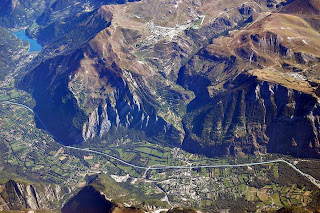
By now, I was staggered by how high we had climbed as spectacular views appeared over Bourg D'Oisans in the valley below. This picture shows Le Bourg D'Oisans in foreground, the climb in the middle and Alpe D'Heuz at the top and is take from www.steephill.tv
 Still there is no let up in the gradient. I rounded a corner to see a camper van with a Union Jack draped over it and shouted (not very loudly), "Come on you Brits", to which I received a huge cheer from the occupants - lovely, it really does keep you going. My unrelenting slow pace continued past Huez village and finally the pitch of the road backed off a little, and it was at this point I could see a Dutch camper van parked up and the family, pouring cold water down the necks of passing riders. I got both the two girls and the Dad to cool me down, which felt fantastic, and I reserved my best "Merci" of the week for them. Why you may ask, the were Dutch - well I worked on the idea that their French was a good deal better than my Dutch.
The beatuful Amanda was waiting for me at bend number 1 just before the "Flamme Rouge" (meaning red kite) and is above the road at the one km to go mark. She didn't see me coming until the last moment and almost missed me.
Once past the 1 km mark the road flattens a bit for the first time and goes past numerous bars and eateries - I don't think many of the riders will appreciate the guys cheering here while taking sips of their ice cold beers, but still the thought was there.
Past our future hotel and maybe 500 metres of downhill - then the final left hand turn, and you've guessed it, a final uphill section to the line. I can remember seeing this and turning to the guy at the side of me and saying "Oh for crying out loud".
I crossed the line in a blaze of sweat and jelly legs while "You can leave your hat on", by Tom Jones (from the Full Monty) played over the loud speakers. There were hundreds of people around the finish and I have to honest and the ladies were going mad at this music, I decided not to perform a striptease at this time as I thought they would be most disappointed.
I recorded a short message just after I finished as Amanda could not get there in time so I don't have an actual shots of me crossing the line - I do have it on video so I will post that as soon as I can.
And that's it really. I got my medal and goody bag and freewheeled back to the hotel, where Amanda meet me with an ice cold Coke - bliss.
 I will detail the remainer of the trip in a fresh post but before I finish there are a few people that I would like to say a massive thank you to.......
Firstly my wife Amanda, without which none have this would have happened (mainly because she paid for the whole trip), but also for her unwavering support (excluding the Col Des Saisies - see later post), including training rides and even following round in the car taking photos and video. What a rock.
Secondly Fred and Jenny Hawkes, my awesome parents who have covered their lack of interest in cycling so well, that I am still fooled. They have help raise money (by pestering half on Nottingham), constantly listening to me going on about hills and cycling stats and are just such great people....
and finally Sally at the Alzheimer's Society, Nicola and Parkinson's UK and everone who has sponsored me and help me raise a ton of money.
I you have read all of this Chapeau to you. It probably took you couple of days, and I'm afraid you will never get that back, and if you sponsored me too, you will never get that back either - but it has gone to one of two great causes and will hopefully benefit many of us in the future.
Thanks, and P.S, I watched the pros do the same stage today and it was great to see them suffer too. At least we went over the top of the Galibier and not through the tunnel as they did.
Saturday, 2 July 2011
Well.... I did it :-). The Most Miles yet I mean...
At 5.50am the following morning I left the house with the intention of riding the Southern Sportive route that I took part in last September, but by starting at home and intercepting the route at West meon, the route was set to be a total of over 125 miles (it ended up being 129.1 miles after I took a wrong turn when I wasn't looking at my sat nav).
Again the main idea was to ride in the heat of the day and really push myself.
I did that completing the route in 7 hours 49 minutes, at an average speed of 16.5 mph, which I am very pleased with given the length of the ride and the fact that I was cycling alone.
A big thanks goes to Paul, of Paul's Pit Stop - who seemed to be the only place open, anywhere to get a cold drink and a re-fill of water.
I drank 5 litres of water and still weighed two pounds less when I got home.
I completed all the climbs in good style including Duncton Hill and the climb immediately out of West Marden, both of which I got heavy cramp when I rode them in the Southern Sportive.
Just one weekend of training to go before I head off to France..... Really starting get excited now.
Sunday, 26 June 2011
Two Weeks Tomorrow
Its Sunday 26th June and the Etape is now two weeks and one day away.
The weather has been terrible of late - gone have the dry days of April and May, leaving June as a near wash out, which has meant that training has been at a premium, with just a couple of runs out with Amanda of note.
This weekend though, Amanda was visiting her parents and I had to work on both the mornings. Not ideal, but I felt quite tired yesterday and chose to spend the day around the house, stretching and reading a book ( about a famous Italian cyclist called Marco Pantani).
Looking at the weather forecast though, we are sheduled to get two very hot days (at least for the UK) on Sunday and Monday before the weather breaks again.
This seemed to be too good an opportunity to miss as one of the factors that I have not been able to train for is the potential heat that I may be facing in France. So I booked the Monday off work and decided that I wold give myself two really punishing days in the heat to really test myself.
I got back from work, got the Madone ready and headed off for the New Forest - not with a route planned but I had a fair idea of where I would go.
After early morning fog, the sun had now burned it's way through and it was starting to become very warm as I reached the Forest and headed up Shepherd's Gutter Lane (for those of you that know it) and on toward Bolderwood - the idea being to circle round and climb back up Bolderwood Ornamental Drive, which is about as hilly as the New Forest gets.
It was apparent that there was a time-trial event in full swing and as I turned onto the climb I started to overtake a few riders and surprised myself with the energy that I had 30 miles or so in. As I continued I passed more riders and was starting to feel quite pleased with myself - especially as I overtook a guy on a full TT bike with aero bars and deep-rimmed carbon wheels.
Best day on a bike for a while and a finishing average speed of 19.9 mph (doh! - so close to evens), for 51 miles, which I am delighted with. Tomorrow the idea is to complete the southern sportive route from home so it sould be about 120 miles, in the heat - hard training indeed!
In the meantime I am going to do exactly what I am doing now - sit in the garden and drink gallons of water. I think I have deserved it today. Until tomorrow.....
Sunday, 12 June 2011
Oh Crud!!
This seemed like a good idea at the time but now I am not so sure....
After completing the Dragon Ride with it's Alpine-like feel and hills, I thought it might be a good idea to compare the profile with that of the Etape that I will be facing in a month.
So here it is...
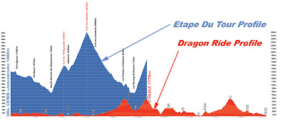 The Dragon Ride is much longer of course but just check out the difference in elevation - I know the starting points are higher but still - Flipping 'eck.
That'll be another know to the confidence then.
After completing the Dragon Ride with it's Alpine-like feel and hills, I thought it might be a good idea to compare the profile with that of the Etape that I will be facing in a month.
So here it is...

That'll be another know to the confidence then.
Thursday, 9 June 2011
A Weekend In Wales - The Wiggle Dragon Ride
I have been building up to the Dragon Ride for quite a while now and have heard from many people just how good the route is.
The wide roads and long climbs mean that this area is the closest thing to the Alps in the U.K.
It was also set to take me to Wales for the first time for anything longer than a flying visit.
Amanda had done her usual sterling work in finding us somewhere nice to stay, despite us booking a little bit later than we probably should have. The Heron's Brook Bed and Breakfast in Blackmill, proved to be a lovely retreat - lovely views, comfortable room and the best bit, a huge corner bath.
As we got there quite early, we unloaded the car, grabbed a quick cup of tea and decided that it would be prudent to go and check some of the route. Not least because some of the major climbs were just a few minutes (in a car at least) from where we were staying.
Twenty minutes away and we had our breath taken away by the beauty of the Bwlch.
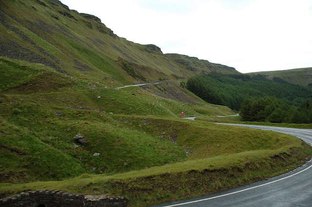 This is in fact the way that we would come down after the final ascent off this mountain - and what a thrill it proved.
Our short drive also took in the climb of the Rhigos - which my 200km route took in but Amanda's 120km route did not. Again we marvelled at the sweeping bends and spectacular views.
 Once back at the Heron's Brook we got changed and set off to the pub to see if we could find pre-ride grub. We both ordered pasta dishes - with a side order of pasta. It was really hot in the pub and after we had eaten so much, we felt really drained and after finishing off with a shandy, headed back to bed.
I am an early riser and Tricia (owner of Heron's Brook) had kindly offered to get up early to organise us some breakfast for 6.45am. By this time though I had already got the bikes loaded onto the car and Amanda was organising the mass of things that we needed to take. We checked the weather forecast and it was not looking good - heavy showers and possible thunderstorms - meaning we would have to carry a good deal more than we had hoped.
Breakfast was duly dispatched and we set off for the start - alongside the Sony factory at Pencoed - only fifteen minutes away.
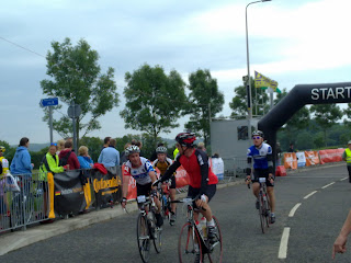
We could not believe the sight that greeted us. It was 7.30am and already there were hundreds of cars queuing to get in.
By the time we had parked, got the bikes off the car, readied all our kit and got to the start point there must have been a thousand riders in a long line between railings, stretching off into distance. I remember thinking that it looked a little bit like the start of the London marathon.
The queue moved quickly as people were being started in groups at short intervals and before we knew it we were heading off to the music from Pirates of the Caribbean.
We had only just got past the first corner when Amanda told me to go ahead and ride my own pace (see her entry at the bottom of this post) - so I duly departed a set off up the next small climb, to see someone already repairing a puncture. What a nightmare that must have been so close to the start.
The initial part of the route headed towards Bridgend along nice roads and as usual in these events, was typified by some riders going too fast early on and overtaking in silly places, where there are just too many riders still. Funny thing is I have now learned to chuckle at this because, although some of these guys are very good riders, the vast majority are regular cyclists who get carried away and set of too fast, and the chance are that you will see them again later when they have blown up and you pass them as they grovel in the gutter with nothing left.
The pace was quite fast early on and I managed to avoid a few early incidents - mainly riders not holding their position in the road (moving sideways off their line) and quite a number of water bottles coming off on bumpy road surfaces and instantly being squished by the wheels behind.
We by-passed Bridgend and turned north-west through Wick and through the lovely Ogmore By Sea, which offered beautiful views of the sea to the left. We swept right alongside the Ogmore River estuary and another water bottle bit the dust.
The next place of note was Porthcawl, a typical busy seaside town and a fair few people cheering us on. It was here that the first feed station was located. I was feeling good though and had plenty of supplies though, so I kept going and continued with regular gulps of water, the odd energy bar and plenty of jelly babies.
We continued to make good progress as we had now settled into a reasonable group and as we headed out of Port Talbot we saw the sign for the first major climb of the day the "Bwlch", which was over 13 miles of climbing!
The first section is not steep at all and the climb in earnest does not start until you have been through the small village of Cymer. From there the road steepens and hugs the left hand side of the mountain. The trees disappear to give a much more rugged feeling and once round a couple of bends, you can see the road right the way up to the top - with ascending cyclists looking like dozens of ants crawling to the top. Looking up at the final section, the road sweeps round a long open bend to the left and appears to steepen dramatically, but fortunately it is an optical illusion and the pitch actually becomes less severe. One more bend back to the right and we were at the top.
 Virtually the whole climb was into the breeze and I spent most of the climb sheltering behind other riders. Not proud of that but I figure that I would be glad later on.
The second feed station was at the top and I was greeted by a very kind member of the local Rotary Club who filled my water bottles up for me and pointed me in the direction of the sustenance.
With the first major climb gone and 52 miles completed, it dawned on me that I was still not even half way round so I got quickly back on and headed off towards the awesome descent down in to Treorchy.
really long and fast and having overtaken a couple of other riders, my confidence in my new tyres was beginning to improve. At which point I was overtaken by another guy who went past like a bullet (it made me jump as he came up on me so quickly - I was doing 43 MPH at the time!).
A short stretch through the town bought us straight the bottom of the second major climb - The Rhigos - a climb of around four miles and a similar pitch to the Bwlch.
 Again it was just a case of getting a rhythm and sticking to it.
I arrived at the top feeling pretty good and prepared myself for another break-neck decent the first part of which was even more intense than the previous. (See second Picture Above).
This descent lasted ages, flattened off and then descended again, so much so that my arms, wrists and fingers were aching by the time I reached Glen - Neath.

Then came something of a sting in the tale.....
I had looked through the profile and seen the major climbs and thought to myself that there was not much else of significance - wrong.
Turning right we started a climb that I had not paid too much attention to, Coelbren. Not a particularly steep or long climb, but coming where it did, after a long descent, where the muscles have started to cool down it was a brute. The rider directly in front of me got cramp, couldn't unclip his feet quickly enough and fell in a heap into the roadside verge. I plodded on and was so glad when I reached the top and got into a group for the next fast section to Neath, where we came upon another short tough climb (Cimla). Which was made all the easier thanks to the large numbers of people who had come out to cheer us all on! This was quickly followed by the final feed station and a banana gorging session.
The only thing that remained (or so I thought) was the second ascent of the Bwlch and it really was a slog.
Starting around the 95 miles it is the Dragon's equivalent of Hardknott Pass on the Fred Whitton, but whereas Hardknott is all you can do just to get up, this is more like a slow death. Not only does it go on for such a long time, but you have already covered it once and it plays with your mind.
It was here that I saw the only spots of rain on the whole ride (Amanda would later tell me that she was caught by a real cloud burst), and I could see my breathe as the top approached.
Over the top again and down the third and as yet unvisited side at a slightly more cautious pace now that the roads were wet . This road though is awesome, carved through the rock, twisting and turning, with waterfalls at various points, and a marshall at the bottom stopping the traffic as you come to the roundabout - what a great idea.
Just one climb remained now and it was the steepest of the day. The finish line was only nine miles away now though and I hooked onto a couple of really fast guys and followed their wheel all the way in - truth be known, it was all I could do to hang on (31 MPH on the flat).
 I arrived to see Amanda clapping me in, picked up my medal and pasta and was delighted to listen to Amanda telling me what a great day she had also had.If you are thinking of a top class sportive to try I can highly recommend the Dragon Ride. It is by far the best route and the best organised event that I have taken part in so far.

Here is the video from my day...... Enjoy in HD too.
Here is Amanda's take on the day.....
For me this was a fantastic day of firsts!
I'd studied the route description and profile so much over the last week that I thought I was prepared for what my 120km would throw at me, so after blowing Alex a kiss and waving goodbye to the cloud of dust he left as he sped off into the distance I settled myself into an easy pace and let the fast boys and girls go. But to my surprise the three so called short climbs early in the ride turned out to be nothing more than short inclines so as the next group of riders overtook me I thought to myself with a little effort I can get their wheel, go at their pace and save my energy for the big climb to come.
Alex would have been proud of me, after the months of badgering me to stay on his wheel and ride close I was doing it, I was keeping up, I was following the hand signals, giving my own, riding fast but not too fast that I was tiring myself out or missing the fab views but fast enough to make the first feed station at the 30mile mark in 1hr and 45 mins - I couldn't believe it.
I enjoyed it so much that when I needed to take off my rain jacket (it hadn't rained yet but I was cold at the start) I didn't want to lose the group by stopping so I took it off whilst still riding and stuffed it in my pocket, unfortunately this wasn't a no-handed first but a first all the same.
The nice thing about being a lady on a predominately male event is that the men had to queue for the loo and the ladies didn't. After re-filling my water bottle & grabbing a banana I set off for the 2nd leg of my adventure.
More Alex advance was ringing in my ears "make sure you eat and drink regularly" so after a few miles and knowing the Big one was coming I decided to eat an energy bar, well it was more like eating cardboard but with half a bottle of water I forced it down.
As I turned right and started the 13mile climb up the Bwlch I felt good and strong, my legs weren't tired and I soon found myself overtaking other riders - male & female (some of which had sped past me in the early miles and were now suffering for their early efforts). This was my next first I had never before overtaken anyone on a hill!
As Alex says above the climb doesn't properly start until you pass through Cymer, I was still feeling good and had settled into a nice rhythm, the views were great and the line of cyclist going off into the distance as the road wound it's way up was amazing. I experienced the same feeling as Alex as you go round a right hand bend and see the road winding off to the left then right it appears that the gradient kicks up, I'd been climbing for about 10 or 11 miles by now and my legs were aching but I still had a few gears to go and thought I can't change down because I'm going to need them. But was an optical illusion as I turned the corner, the breeze dropped the gradient relaxed and I changed up and powered to the top.
After a short break to refill my water bottles and grabbed another banana I put my jacket back on and started the best descent of my life, I had the road to myself, no cars and the riders that set off just before me were no where to be seen. I don't know how fast I went because I didn't dare take my eyes off the road for a second but it was fast.
At the bottom I took my jacket off again - without stopping and headed for the last short tickle of a hill again I passed another male cyclist on the ascent. After another fast descent it started to rain and I finished the last 10k or so in an absolute downpour.
I didn't mind being wet I finished my 70 miles in 4 hours and 31 minutes - I'd said I wanted to do it in less than 6 hours but really hoped for between 5 and 5.5 this was my last first of the day - I have never ridden 70 miles in under 5 hours.
The day was amazing it was made by the lovely cyclist I shared the work & chats with, the spectators that cheered us on and Alex's constant support and encouragement to always improve that prepared and trained me to ride in groups and climb well.
I'm supposed to be Alex's support and motivator for the Etape but of late it has been the other way round - Thank you!
The wide roads and long climbs mean that this area is the closest thing to the Alps in the U.K.
It was also set to take me to Wales for the first time for anything longer than a flying visit.
Amanda had done her usual sterling work in finding us somewhere nice to stay, despite us booking a little bit later than we probably should have. The Heron's Brook Bed and Breakfast in Blackmill, proved to be a lovely retreat - lovely views, comfortable room and the best bit, a huge corner bath.
As we got there quite early, we unloaded the car, grabbed a quick cup of tea and decided that it would be prudent to go and check some of the route. Not least because some of the major climbs were just a few minutes (in a car at least) from where we were staying.
Twenty minutes away and we had our breath taken away by the beauty of the Bwlch.

Our short drive also took in the climb of the Rhigos - which my 200km route took in but Amanda's 120km route did not. Again we marvelled at the sweeping bends and spectacular views.

I am an early riser and Tricia (owner of Heron's Brook) had kindly offered to get up early to organise us some breakfast for 6.45am. By this time though I had already got the bikes loaded onto the car and Amanda was organising the mass of things that we needed to take. We checked the weather forecast and it was not looking good - heavy showers and possible thunderstorms - meaning we would have to carry a good deal more than we had hoped.
Breakfast was duly dispatched and we set off for the start - alongside the Sony factory at Pencoed - only fifteen minutes away.
We could not believe the sight that greeted us. It was 7.30am and already there were hundreds of cars queuing to get in.
By the time we had parked, got the bikes off the car, readied all our kit and got to the start point there must have been a thousand riders in a long line between railings, stretching off into distance. I remember thinking that it looked a little bit like the start of the London marathon.
The queue moved quickly as people were being started in groups at short intervals and before we knew it we were heading off to the music from Pirates of the Caribbean.
We had only just got past the first corner when Amanda told me to go ahead and ride my own pace (see her entry at the bottom of this post) - so I duly departed a set off up the next small climb, to see someone already repairing a puncture. What a nightmare that must have been so close to the start.
The initial part of the route headed towards Bridgend along nice roads and as usual in these events, was typified by some riders going too fast early on and overtaking in silly places, where there are just too many riders still. Funny thing is I have now learned to chuckle at this because, although some of these guys are very good riders, the vast majority are regular cyclists who get carried away and set of too fast, and the chance are that you will see them again later when they have blown up and you pass them as they grovel in the gutter with nothing left.
The pace was quite fast early on and I managed to avoid a few early incidents - mainly riders not holding their position in the road (moving sideways off their line) and quite a number of water bottles coming off on bumpy road surfaces and instantly being squished by the wheels behind.
We by-passed Bridgend and turned north-west through Wick and through the lovely Ogmore By Sea, which offered beautiful views of the sea to the left. We swept right alongside the Ogmore River estuary and another water bottle bit the dust.
The next place of note was Porthcawl, a typical busy seaside town and a fair few people cheering us on. It was here that the first feed station was located. I was feeling good though and had plenty of supplies though, so I kept going and continued with regular gulps of water, the odd energy bar and plenty of jelly babies.
We continued to make good progress as we had now settled into a reasonable group and as we headed out of Port Talbot we saw the sign for the first major climb of the day the "Bwlch", which was over 13 miles of climbing!
The first section is not steep at all and the climb in earnest does not start until you have been through the small village of Cymer. From there the road steepens and hugs the left hand side of the mountain. The trees disappear to give a much more rugged feeling and once round a couple of bends, you can see the road right the way up to the top - with ascending cyclists looking like dozens of ants crawling to the top. Looking up at the final section, the road sweeps round a long open bend to the left and appears to steepen dramatically, but fortunately it is an optical illusion and the pitch actually becomes less severe. One more bend back to the right and we were at the top.

The second feed station was at the top and I was greeted by a very kind member of the local Rotary Club who filled my water bottles up for me and pointed me in the direction of the sustenance.
With the first major climb gone and 52 miles completed, it dawned on me that I was still not even half way round so I got quickly back on and headed off towards the awesome descent down in to Treorchy.
really long and fast and having overtaken a couple of other riders, my confidence in my new tyres was beginning to improve. At which point I was overtaken by another guy who went past like a bullet (it made me jump as he came up on me so quickly - I was doing 43 MPH at the time!).
A short stretch through the town bought us straight the bottom of the second major climb - The Rhigos - a climb of around four miles and a similar pitch to the Bwlch.

I arrived at the top feeling pretty good and prepared myself for another break-neck decent the first part of which was even more intense than the previous. (See second Picture Above).
This descent lasted ages, flattened off and then descended again, so much so that my arms, wrists and fingers were aching by the time I reached Glen - Neath.

Then came something of a sting in the tale.....
I had looked through the profile and seen the major climbs and thought to myself that there was not much else of significance - wrong.
Turning right we started a climb that I had not paid too much attention to, Coelbren. Not a particularly steep or long climb, but coming where it did, after a long descent, where the muscles have started to cool down it was a brute. The rider directly in front of me got cramp, couldn't unclip his feet quickly enough and fell in a heap into the roadside verge. I plodded on and was so glad when I reached the top and got into a group for the next fast section to Neath, where we came upon another short tough climb (Cimla). Which was made all the easier thanks to the large numbers of people who had come out to cheer us all on! This was quickly followed by the final feed station and a banana gorging session.
The only thing that remained (or so I thought) was the second ascent of the Bwlch and it really was a slog.
Starting around the 95 miles it is the Dragon's equivalent of Hardknott Pass on the Fred Whitton, but whereas Hardknott is all you can do just to get up, this is more like a slow death. Not only does it go on for such a long time, but you have already covered it once and it plays with your mind.
It was here that I saw the only spots of rain on the whole ride (Amanda would later tell me that she was caught by a real cloud burst), and I could see my breathe as the top approached.
Over the top again and down the third and as yet unvisited side at a slightly more cautious pace now that the roads were wet . This road though is awesome, carved through the rock, twisting and turning, with waterfalls at various points, and a marshall at the bottom stopping the traffic as you come to the roundabout - what a great idea.
Just one climb remained now and it was the steepest of the day. The finish line was only nine miles away now though and I hooked onto a couple of really fast guys and followed their wheel all the way in - truth be known, it was all I could do to hang on (31 MPH on the flat).
 I arrived to see Amanda clapping me in, picked up my medal and pasta and was delighted to listen to Amanda telling me what a great day she had also had.
Here is the video from my day...... Enjoy in HD too.
Here is Amanda's take on the day.....
For me this was a fantastic day of firsts!
I'd studied the route description and profile so much over the last week that I thought I was prepared for what my 120km would throw at me, so after blowing Alex a kiss and waving goodbye to the cloud of dust he left as he sped off into the distance I settled myself into an easy pace and let the fast boys and girls go. But to my surprise the three so called short climbs early in the ride turned out to be nothing more than short inclines so as the next group of riders overtook me I thought to myself with a little effort I can get their wheel, go at their pace and save my energy for the big climb to come.
Alex would have been proud of me, after the months of badgering me to stay on his wheel and ride close I was doing it, I was keeping up, I was following the hand signals, giving my own, riding fast but not too fast that I was tiring myself out or missing the fab views but fast enough to make the first feed station at the 30mile mark in 1hr and 45 mins - I couldn't believe it.
I enjoyed it so much that when I needed to take off my rain jacket (it hadn't rained yet but I was cold at the start) I didn't want to lose the group by stopping so I took it off whilst still riding and stuffed it in my pocket, unfortunately this wasn't a no-handed first but a first all the same.
The nice thing about being a lady on a predominately male event is that the men had to queue for the loo and the ladies didn't. After re-filling my water bottle & grabbing a banana I set off for the 2nd leg of my adventure.
More Alex advance was ringing in my ears "make sure you eat and drink regularly" so after a few miles and knowing the Big one was coming I decided to eat an energy bar, well it was more like eating cardboard but with half a bottle of water I forced it down.
As I turned right and started the 13mile climb up the Bwlch I felt good and strong, my legs weren't tired and I soon found myself overtaking other riders - male & female (some of which had sped past me in the early miles and were now suffering for their early efforts). This was my next first I had never before overtaken anyone on a hill!
As Alex says above the climb doesn't properly start until you pass through Cymer, I was still feeling good and had settled into a nice rhythm, the views were great and the line of cyclist going off into the distance as the road wound it's way up was amazing. I experienced the same feeling as Alex as you go round a right hand bend and see the road winding off to the left then right it appears that the gradient kicks up, I'd been climbing for about 10 or 11 miles by now and my legs were aching but I still had a few gears to go and thought I can't change down because I'm going to need them. But was an optical illusion as I turned the corner, the breeze dropped the gradient relaxed and I changed up and powered to the top.
After a short break to refill my water bottles and grabbed another banana I put my jacket back on and started the best descent of my life, I had the road to myself, no cars and the riders that set off just before me were no where to be seen. I don't know how fast I went because I didn't dare take my eyes off the road for a second but it was fast.
At the bottom I took my jacket off again - without stopping and headed for the last short tickle of a hill again I passed another male cyclist on the ascent. After another fast descent it started to rain and I finished the last 10k or so in an absolute downpour.
I didn't mind being wet I finished my 70 miles in 4 hours and 31 minutes - I'd said I wanted to do it in less than 6 hours but really hoped for between 5 and 5.5 this was my last first of the day - I have never ridden 70 miles in under 5 hours.
The day was amazing it was made by the lovely cyclist I shared the work & chats with, the spectators that cheered us on and Alex's constant support and encouragement to always improve that prepared and trained me to ride in groups and climb well.
I'm supposed to be Alex's support and motivator for the Etape but of late it has been the other way round - Thank you!
Monday, 30 May 2011
A Year's Progress
We've come along way in a year, Amanda and myself......
Just over a year ago, we cycled a sportive event called the Hampshire Hilly Hundred - Amanda to raise funds for the Alzheimer's Society and me, to help her along the way and provide support.
Amanda found it very tough and completed the 98 (or so) miles in a little under 8 hours.
Yesterday we did the route again (starting from home to increase the miles a little bit), as training for next weeks Dragon Ride in Wales, where Amanda is set to complete 75 miles and I will complete 126 miles, as further training towards the Etape Du Tour in July.
I got home from work and we hit the road at around 10am, heading towards Twyford to intercept the route and soon ran into the first hill of the day - White's Hill, leading to Owslebury. We have cycled this a few times since but vividly remember how much of a shock this hill was when we first did it last year. Turning of the main road, not long after the waterworks building, the road narrows to a single track and works its way through woodland before suddenly steepening from nowhere and reaching 17%. It's not long but tricky if you are not expecting it. We both found it considerably easier than in last May though.
We have also come along way in terms of our knowledge of how our bodies will react and the kind of nutrition we need to have in order to keep going - Jelly babies seem to be the best discovery. Plenty of instant energy, easy to digest and you can take them in small amounts, and most importantly, regularly. With a good breakfast, plenty of water and an electrolyte drink to aid hydration and prevent cramping we managed our nutrition throughout the day.
Winchester Hill and Beacon Hill are not as challenging as they once were and once over them we headed northwards and on towards the top section of the route on the far side of the M3.
At 50 miles in we stopped at Overton to refresh our supplies (not the same scenes of desperation eating ( see earlier post) that greeted my solo trip past here in December).
We timed our most sustained eating for the 3 or four miles immediately before Watership Down but in truth this hill has lost most of it's reputation. It consists of two steep sections with a flat run in between. It was so tough last year because it comes 62 miles in and we were a good deal less fit back then ( we were also both 10 pounds heavier).
As we approached Farley Mount, with around 90 miles on the clock, I realised that if we took the most direct route home from here we would not reach the 100 mile mark.
I indicated to Amanda that we would need to go all the way back to Twyford and then home to make sure we went over the ton. She was now becoming very tired and fortunately for me, could not catch me up to strangle me.
We arrived home more than an hour quicker than the year before and did five miles more. Our average speed was 2 mph faster and I certainly had a good bit more in the tank, which was a welcome confidence boost.
Onwards to Wales now for the Dragon Ride, which I am really looking forward to as Wales is a place I hardly know and I will hopefully have some pics and video to give a flavour of the day.....
Sunday, 15 May 2011
Al Goes to Fat Camp - Day 3
As many people had left on the previous evening, it had been decided that only one group would go out on the final day for a short 30 mile ride to stretch our legs. It had also been decided that the group would go at a nice steady pace as everyone was tired and like myself, faced a substantial trip home.
Heading North out of Skipton the ride was just that, a nice gentle roll round. Then a rider had a chain snap, and the group took a few minutes out while a repair was made.
As the morning progressed I became increasingly aware of a new rider that had not been with us on the previous days. He clearly had fresher legs than us and was determined to force the pace, although it was funny to watch as the group "hung him out to dry" and no one followed him, forcing him to stop and wait - with a thoroughly disgruntled look on his face.
It was inevitable though that as the end of the ride came, the stronger riders began to pull away from the group and a bid for first to the hotel was being made. Everyone let the new face sit on the front and just sheltered behind him, knowing that he would simply ride himself into the ground, and so it proved.
We entered Skipton on the final run in and myself and the new guy managed to anticipate the traffic and pulled far enough clear of the rest that they would not be able to catch us back up. From there, I simply sat on his wheel and waited until about 500 yards to go before sprinting to the finish and leading the way into the hotel car park in a completely meaningless and childish display of waining strength - still, I was really pleased to have finished strongly, it's good for the confidence levels.
It brought to an end a thoroughly enjoyable and informative weekend and one that will hopefully set me up nicely for the Etape in what is now less than two months time.
I am now really starting to look forward to the trip to France and with the fundraising having gone well in the last month or so, I feel that things are now starting to come together.
Anyone that reads this blog and would like to sponsor me for either Parkinson's UK or the Alzheimer's Society can do so by clicking the following links http://www.justgiving.com/Alex-Hawkes-Parkinsons-UK or http://www.justgiving.com/Alex-Hawkes-Alzheimers - Many thanks in advance.
In the meantime, here is a short video that I have created showing some of the sights of the weekend.
Tuesday, 10 May 2011
Al Goes to Fat Camp - Day Two
Once again I rose early on the Sunday morning and, with only a little soreness in the legs, was very glad that I had taken the time to stretch my muscles before going to bed the night before.
This ride, the second of three was slightly shorter than the first day at 60 miles and only had three climbs of note.
Breakfast was duly dispatched and I readied myself and the bike for another fast, long day in the saddle with the fast group, and to my surprise, all the same people put themselves up for the challenge for a second day (although one would later drop back into the slower groups after suffering cramp).
We headed off again through Skipton but then turned North West and on to the first climb of the day, Scosthrop Moor, which was challenging but more memorable if truth be known for the descent into Settle which was fast, twisting and utterly unnerving thanks to a rippled road surface which constantly threatened to destroyed any control that you had over the bike. More interesting though was that at the bottom, the welcome into Settle was in the form of cobblestones - ouch!!
The first feed station was located here and after a short session of taking on all the food and drink that you could we turned right and with the warning "make sure you are on the small ring here" (i.e. your easiest gears, indicating a nasty climb). They were not kidding, immediately the road narrowed and swept left, steepening rapidly. Fortunately this was short lived and the, now single track road levelled and followed a hedge line before meeting up with the main road.
A right turn later and we began the main climb of the day - Heading almost North from Stainforth, we turned into what was again a howling wind and the road was very steep at the start.
To use a cycling commentary term, the steepness of the road, coupled with the headwind "blew the group to pieces" and I ended up in the second of four groups, trying to play a cagey game by shielding behind another two riders. Eventually though, one rider dropped away and just myself and Darren continued to the top.
The gradient had now relaxed somewhat and although the wind got even stronger as we ventured further out on to the moor. Courtesy of www.sportivecentral.com

I was becoming aware of a mountain to our left-hand side , and it looked strangely familiar. It almost looked like a forehead...... Darren told me that it was Pen -y - Ghent. Now it made sense as I had been camping there with my Dad many years ago when we did the Three Peaks walk.

Quite a sight. This just about signalled the summit and a long flat stretch which then descended (very steep and fast again), to Halton Gill where the second feed station awaited.
The next section followed the river Skirfare before swinging left over open grassland over to the far side of the River Wharfe, through Hebden and the delightfully named Appletreewick.
A quick descent and a sharp right turn over a very narrow bridge and we were nearly at the final climb - Halton Moor. The group had to stop though as Darren's chain had snapped. He indicated to us that we should carry on (as luck would have it the owner of the local bike shop was in the pub nearby having Sunday lunch and just happened to have his tool kit in the back of his van).
We pressed on up what was a very nice steady climb. My legs were very tired though and I got dropped on the climb and ended up finishing the ride on my own - my only comfort being that I did get back to the hotel a creditable second.
Better still, we were back in time to grab a quick shower and watch the football. I sat there and stuffed my face with all the post ride recovery freebies that we had been given.
Another ride tomorrow and not too sure whether the legs will be up for it.
Saturday, 7 May 2011
Al Goes to Fat Camp - Day One
What a fantastic thought that my Mum and Dad had last October, to send me to training camp in the Yorkshire Dales, organised by Sports Tours International.
I laughingly referred to it as "fat camp", but I knew all along that this would be a hard three days and no laughing matter at all.
Having researched the routes in the week leading up to the trip, I realised that this would be hilly terrain to say the least and that at least two of the climbs were in my book of 100 greatest cycling climbs, notably Buttertubs Pass and Fleet Moss.
And so it was that I set off Northwards after being at work, and after making good progress, then hit a huge traffic jam on the A34 and sat in the car with the engine off for over half an hour. Some six hours later, and thoroughly worn out after a long drive and a 4.30 am start, I arrived at The Rendezvous Hotel in Skipton and got checked in to my room. A single occupancy was a sound idea since I knew that rest would be a premium and I could "spread out". Before I knew it, the time had reached 7pm and it was time for the welcome meeting and a briefing on how the weekend was likely to pan out. Three groups would go out each day to accommodate a range of cycling levels. The question now dawned, which group to go in, and this became the topic of conversation over dinner with a group of guys many of whom had completed previous Etapes and had fascinating stories to tell of their exploits.
We all retired early and I continued to contemplate which was the best group to go with... this thought stayed with my right through until the next morning.
I awoke early as I often do and found myself with some time on my hands before breakfast was available so I got all my kit lined up and pottered down for a leisurely pre ride fuelling session, before we were set to meet up for the ride at 9am. The plan was that the slowest group would go out first, followed by the middle speed group, with the fast group going out last. I was toying with the idea of going with the second group but after chatting to the leader of the fast group, I thought to myself that I had come here to train, not to just amble round and take it easy - the fast group it was.
We set off on what was a 90 mile route with four notable climbs, although the road was never really flat at any stage...... Heading North out of Skipton the early part of the route was gentle enough, and the pace was fast but no so fast that weren't able to take in the increasingly beautiful surroundings of the Yorkshire Dales
Our ride leaders indicated to us that the first climb of the day had arrived as we passed through Buckden, known as Kidstones. Profile from www.sportivecentral .com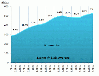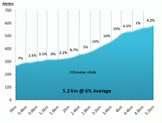

This was a lovely climb with a few steep sections and sweeping hairpin bends but it was more notable for me for that fact that my chain jumped off during a double gear change. Just as I tried to use the front derailleur to re align my chain, I felt a hand on my back, pushing me for just long enough for me to get my chain back on without stopping. It was Darren, one of the ride leaders who has been alert enough to see/hear what had happened and helped my out before it became a problem - a great help.
Following a fast descent and a water stop we proceeded towards the second marquee climb of the day - Redmire Moor. Approaching from the south west you see the impressive site of Castle Bolton on the left, before climbing up onto open moorland. Profile from www.sportivecentral .com
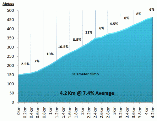
As you can see this is a significant climb and with the strong headwind, this was a climb not to be underestimated. I really enjoyed it actually as I always think that you might as well make the training as difficult as possible.
The descent was pretty scary, I found. Paul, Darren and a couple of our guys fairly hurtled down this narrow, twisting, wall-lined road. The howling wind gusted and did it's best to throw you off line. I just held on tight and went down as fast as I dared.
The next stretch took us through rolling Dales countryside and past river (although fairly dry) and on towards Thwaite, which signalled the first major climb of the day - Buttertubs Pass, rated at 8 out of 10 in my book of cycling climbs. Profile from www.sportivecentral .com

Turning left off the main road, the start is not too difficult but ahead you can see the road steepening and swinging first right and then left in alpine-hairpin style.
The pace had been quite hard up to this point and a few of the guys had been left behind. meanwhile Alistair, who I had been chatting to and, it turns out, lives only a couple of miles away from me shot off. Not attacking but just riding away, and having established that he is a triathlete, I made no attempt to try and keep up with him.
Alistair was waiting at the bottom of the descent and I joined him to wait for the others to catch up. Glancing south and saw what appeared to be a road going over a very steep hill in the distance - it looked familiar too, having had a good look at the climbs prior to the ride. Yes it was the final climb of the day, Fleet Moss - the highest road in Yorkshire and it looked horrendous from this distance. Profile from www.sportivecentral .com

We headed through Hawes and just as the 100 Best Cycling Climbs indicated, the road climbs steeply at first before all but levelling off. It really is toying with you though as, once you pass all the farm buildings, all you can see is a really big hill, and the road simply takes the shortest route over it. No hairpins to soften the gradient, just straight up and over, and it it just gets steeper and steeper, finishing off with a brutal section of around 20% when your legs are in tears. Once over the road flattens before a short final 18% ramp to complete the climb.
The descent that follows is terrifying - twisting blind corners, uneven road, very steep and a cross wind. Concentration is the key and by the time we had got to the bottom my eyes were nearly popping out of my head.
The final section of the ride seemed to take for ever as my legs, arms and wrists were all tired and all I wanted t do was get back and rest (and have a beer).
We all gave it our best effort to get back to the hotel and with a few mile to go, myself and Alistair had dropped the rest of the group, and the two leaders had gone back to make sure that they were OK.
The two of us eventually reached the hotel together and shared a handshake as we came into the car park together.
A few beers, a seminar on the Etape route and a hearty supper later, my head hit the pillow and that was the end of the end of day one.....
Saturday, 9 April 2011
L'enfer Du Nord - The Fred Whitton Four Seasons - Take Two
Please note all the photos can be clicked on to see the full size picture.
With due deference to the famous cycling race, Paris-Roubaix,(aka L'enfer du Nord - The Hell of the North), the Fred Whitton Challenge could easily take on the same name for someone like me who lives in the south of England.
After having to abandon the challenge on Monday 4th April (see previous post) due to horrendous weather, we continued to check the weather forecast for another window of opporutnity - Wednesday seemed to be a good day following a wet start - Thursday seemed even better.
Amanda's sister Jenny had arrived for a couple of days break and decided to tag along in the support vehicle to keep each other company - really kind of her as she is not a cyclist and must have been pretty bored, but it was a real help to Amanda.
It had rained all of Tuesday and following the 50 mile abandoned ride we spent Tuesday walking around the Aira Force waterfall near Ullswater - not the ideal preparation for the legs but the whole week did not quite go as planned in a cycling sense.
At 5am on Wednesday 6th April we awoke to ....... rain. Never mind, it was forecast and was scheduled to clear up fairly early, so we got the car loaded up (putting my cycling shoes in first).
As we drove to Coniston and the start point it was throwing it down again, and there was more than a little aprehension in the car as we could see it all happening again. Amanda was very quiet, I just wanted to get going and Jenny just thought we were both mad (she was probably right).
This time though, things were different. We had remembered my shoes, my mp3 player and I didn't drop my phone - bonus.
 And so it was that I "dobbed" my card in at the start point and got underway, heading for the first climb of the day at Hawkshead Hill.
I remember enjoying this climb first time around and this was even better now that I had the correct footwear on. It was still raining, if more lightly, but it was still pretty dark.
 Things continued to improve when I also didn't take a wrong turn at the top of Hawkshead Hill, and headed down the descent - carefully. The roads were soaking wet and the heavy rain of the previous days had washed a fair bit of debris onto the roads, just making you watch your step a bit.
Moving on around the head of lake Windermere and through Ambleside the rain finally began to ease and this was welcome as I turned left to Troutbeck and began the steep introduction to the start of Kirkstone Pass again.
 I arrived at the top for the fourth time during the week and yet again it was shrowded in fog. You can just about make me out logging in at the checkpoint.
There was so much moisture in the air that the video camera started to pack up.
Heading quickly off down towards Ullswater the road was wet and slippy, so anxious not to create any problems, I took it nice and steady and hit the climb to Matterdale End in good spirits.....
......then I saw it...... The Sun..... admittedly only milky behind the clouds, but neverless it was there.
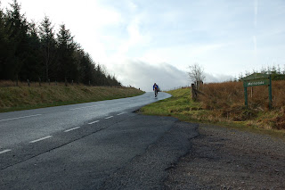 The wind was also beginning to pick up but this was not a problem at this stage - it was just nice to have the sun coming out.
Here you can see the conditions getting better as I start to descend from Matterdale End towards the long stretch along the A66. Not a nice section really, yes it is fast and there is a "safe" strip to the side of the road but this disappears for a while and the wind blows you into the road, especially when it gusts. The "cats eyes" are also very high so are a real potential problem when they are wet.
The next stage of the route takes you through Keswick, past Derwent Water, through Borrowdale and on to Seatoller which is at the base of the first real test of the day, Honister Pass. It was at the top of this climb that I had to abandon on the Monday due to the terrible weather conditions. I took a quick stop at the public loos here and a wringing out of the socks (there was no hand dryer unfortunately) before the climb probably saved me a few extra grams of weight.
 Today was different though, the 25% warning sign at the bottom did not seem quite as daunting with dry roads and a quick look over my left shoulder gave a view of a group of school children "river running" in the gushing water at the side of the road.
I was setting a (very) steady pace, not wanting to tire myself out both in terms of the climb but also because, at 48 miles I was still 8 miles from the half way point.
This climbs teeth are all at the start with a sustained, very steep section which gradually gets steeper until you pass over a cattle grid when the gradient relaxes until a steepening towards the end. Halfway up the steepest section, I realised that my front tyre was starting to go down - I couldn't believe it. The road is so steep here that I was struggling to find a spot to park the bike up so that I could repair the puncture. I put the new tube in, checked the inside of the tyre and used my mini compressor to inflate the tyre. The tyre seemed really hard, but that is the whole idea of the compressor I thought, so I put the wheel back on and got in position to continue - no mean feat when the road is so steep and you have to clip back into cleated pedals....
I must have got five yards maximum before there was a huge bang from my front tyre. I looked down and saw my tyre off the rim - that's it I thought my ride is over - but on closer inspection the tube had blown and the tyre had simply been blown of the rim. My only option was now to repair the original tube and pump it up (by hand), but knowing how long this would take, I thought that I had better ring Amanda and tell her what was going on as she had gone on ahead to go to the slate mine with Jenny- no signal, not for the first time.
 By the time I had repaired the tube and pumped the tyre up I had probably wasted about 20-25 minutes and finally reaching the top of the climb, in strengthening winds, Amanda and Jenny were waiting at the top, frozen, and had not even been in the mine shop as they didn't want to miss me.
As I passed I said that I would meet them at the Buttermere check-in point where I could "stop the clock", use the facilities and wait for them.
Once the girls arrived I replenished my stocks of food and water, changed my soaking wet socks, fully pumped up my front tyre and headed off for my favourite climb, Newlands Pass.
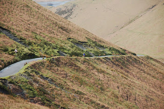 I love the way that the road clings onto the side of the mountain. I think it is the most scenic of all the passes that I have done in the lakes.
The spectacular Moss Force waterfall awaits at the top before that best, fastest and most exhilarating decent on the whole route, as the road is fairly straight and you can see everything in front of you and before you know it you are arriving in Braithwaite and the start of Whinlatter Pass....
 .....which is fairly straightforward with two or three steep sections to keep you honest and the whole climb is sheltered by trees so, no wind and pleasant shade. As you can see from the photo, the sun was now shining and for the first time in the week I took off my rain jacket and stuffed it in my back pocket and looked forward to the descent and the section of the route that I had never done before
 This is the upper section of Cold Fell, which is not the most invitingly named place that I have ever come across but the climb is a nice one with spectacular views to the coast on your right hand side. As the name suggests though it is very open and that meant that the whole climb was straight into the wind - very punishing indeed and my whole body was starting to feel really tired and I was very conscious of not pushing too hard knowing full well what was not too many miles away....
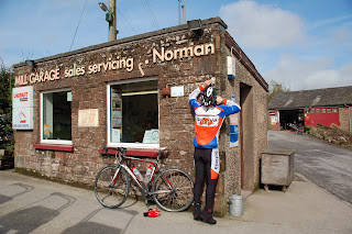 ......but all this is just the prelude of course to the main event. The route now heads through Gosforth and Santon with a short climb up Irton Pike and a descent into Eskdale Green. By this stage though you have cycled about 95 miles and all you can think about is Hardknott Pass.
 The irony is that this is really the longest, flattest part of the whole ride, but as you ride down the Eskdale Valley alongside the railway you get a glimpse of what faces you next. I have read so many peoples accounts of this climb and so many descriptions, but one of my favourites describes Hardknott Pass as looking like "Mordor" in the distance..... but not today. For the first time I was seeing Hardknott in the sunshine, and it really is an incredible sight. The road was built by the Romans and how they managed it, I have no idea.
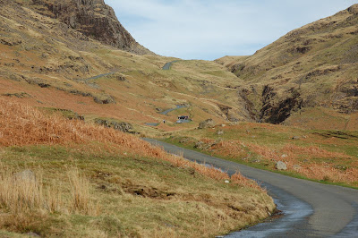
As I looked ahead a car had stalled on the infamous 33% left hand hairpin bend and had had to reverse down and have another go.


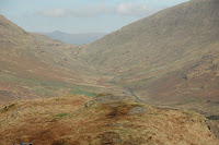 Wyrnose is another formidable climb but it is much easier from this side, and although very steep, is do-able. This picture shows me coming up Wrynose with Hardknott in the background, looking like a river as the road is wet.


 All that remains is to say that I instantly tried to put on some of those calories lost by having the biggest plate of chilli and nachos I could manage, and to be fair, if you have managed to read all of this, you probably deserve some too.
Here is a little video that I have created of the day - and don't forget to watch it in HD - just click the 240 or 360 in the bottom right corner of the player and change to 720.
Next stop, the Dragon Ride......
With due deference to the famous cycling race, Paris-Roubaix,(aka L'enfer du Nord - The Hell of the North), the Fred Whitton Challenge could easily take on the same name for someone like me who lives in the south of England.
After having to abandon the challenge on Monday 4th April (see previous post) due to horrendous weather, we continued to check the weather forecast for another window of opporutnity - Wednesday seemed to be a good day following a wet start - Thursday seemed even better.
Amanda's sister Jenny had arrived for a couple of days break and decided to tag along in the support vehicle to keep each other company - really kind of her as she is not a cyclist and must have been pretty bored, but it was a real help to Amanda.
It had rained all of Tuesday and following the 50 mile abandoned ride we spent Tuesday walking around the Aira Force waterfall near Ullswater - not the ideal preparation for the legs but the whole week did not quite go as planned in a cycling sense.
At 5am on Wednesday 6th April we awoke to ....... rain. Never mind, it was forecast and was scheduled to clear up fairly early, so we got the car loaded up (putting my cycling shoes in first).
As we drove to Coniston and the start point it was throwing it down again, and there was more than a little aprehension in the car as we could see it all happening again. Amanda was very quiet, I just wanted to get going and Jenny just thought we were both mad (she was probably right).
This time though, things were different. We had remembered my shoes, my mp3 player and I didn't drop my phone - bonus.

I remember enjoying this climb first time around and this was even better now that I had the correct footwear on. It was still raining, if more lightly, but it was still pretty dark.

Moving on around the head of lake Windermere and through Ambleside the rain finally began to ease and this was welcome as I turned left to Troutbeck and began the steep introduction to the start of Kirkstone Pass again.

There was so much moisture in the air that the video camera started to pack up.
Heading quickly off down towards Ullswater the road was wet and slippy, so anxious not to create any problems, I took it nice and steady and hit the climb to Matterdale End in good spirits.....
......then I saw it...... The Sun..... admittedly only milky behind the clouds, but neverless it was there.

Here you can see the conditions getting better as I start to descend from Matterdale End towards the long stretch along the A66. Not a nice section really, yes it is fast and there is a "safe" strip to the side of the road but this disappears for a while and the wind blows you into the road, especially when it gusts. The "cats eyes" are also very high so are a real potential problem when they are wet.
The next stage of the route takes you through Keswick, past Derwent Water, through Borrowdale and on to Seatoller which is at the base of the first real test of the day, Honister Pass. It was at the top of this climb that I had to abandon on the Monday due to the terrible weather conditions. I took a quick stop at the public loos here and a wringing out of the socks (there was no hand dryer unfortunately) before the climb probably saved me a few extra grams of weight.

I was setting a (very) steady pace, not wanting to tire myself out both in terms of the climb but also because, at 48 miles I was still 8 miles from the half way point.
This climbs teeth are all at the start with a sustained, very steep section which gradually gets steeper until you pass over a cattle grid when the gradient relaxes until a steepening towards the end. Halfway up the steepest section, I realised that my front tyre was starting to go down - I couldn't believe it. The road is so steep here that I was struggling to find a spot to park the bike up so that I could repair the puncture. I put the new tube in, checked the inside of the tyre and used my mini compressor to inflate the tyre. The tyre seemed really hard, but that is the whole idea of the compressor I thought, so I put the wheel back on and got in position to continue - no mean feat when the road is so steep and you have to clip back into cleated pedals....
I must have got five yards maximum before there was a huge bang from my front tyre. I looked down and saw my tyre off the rim - that's it I thought my ride is over - but on closer inspection the tube had blown and the tyre had simply been blown of the rim. My only option was now to repair the original tube and pump it up (by hand), but knowing how long this would take, I thought that I had better ring Amanda and tell her what was going on as she had gone on ahead to go to the slate mine with Jenny- no signal, not for the first time.

As I passed I said that I would meet them at the Buttermere check-in point where I could "stop the clock", use the facilities and wait for them.
Once the girls arrived I replenished my stocks of food and water, changed my soaking wet socks, fully pumped up my front tyre and headed off for my favourite climb, Newlands Pass.

The spectacular Moss Force waterfall awaits at the top before that best, fastest and most exhilarating decent on the whole route, as the road is fairly straight and you can see everything in front of you and before you know it you are arriving in Braithwaite and the start of Whinlatter Pass....
 .....which is fairly straightforward with two or three steep sections to keep you honest and the whole climb is sheltered by trees so, no wind and pleasant shade. As you can see from the photo, the sun was now shining and for the first time in the week I took off my rain jacket and stuffed it in my back pocket and looked forward to the descent and the section of the route that I had never done before
Normally, the descent from Whinlatter is long and fast but the wind was now fully blowing and was it was really slowing me down as I headed towards the next climb - the beautifully named Fangs Brow - followed by Kelton Fell.
Amanda and Jenny had taken a well earned lunch break at the Whinlatter visitor centre and they did not catch me back up until the climb of Cold Fell.
 This is the upper section of Cold Fell, which is not the most invitingly named place that I have ever come across but the climb is a nice one with spectacular views to the coast on your right hand side. As the name suggests though it is very open and that meant that the whole climb was straight into the wind - very punishing indeed and my whole body was starting to feel really tired and I was very conscious of not pushing too hard knowing full well what was not too many miles away....
The descent from Cold Fell takes you straight to the final check-in station at Calder Bridge.....
 ......but all this is just the prelude of course to the main event. The route now heads through Gosforth and Santon with a short climb up Irton Pike and a descent into Eskdale Green. By this stage though you have cycled about 95 miles and all you can think about is Hardknott Pass.
 The irony is that this is really the longest, flattest part of the whole ride, but as you ride down the Eskdale Valley alongside the railway you get a glimpse of what faces you next. I have read so many peoples accounts of this climb and so many descriptions, but one of my favourites describes Hardknott Pass as looking like "Mordor" in the distance..... but not today. For the first time I was seeing Hardknott in the sunshine, and it really is an incredible sight. The road was built by the Romans and how they managed it, I have no idea.
By the time you see this sight, you have already been through the killer first section,over the cattle grid and past the car park. This is the so called "flat section" which in reality is around a 7% to 9% gradient.

My legs were dead by now and I would like to say that I bombed up without any fuss but that wasn't the case - I did ride every single inch of the pass but I had to stop a couple of times to catch my breath.

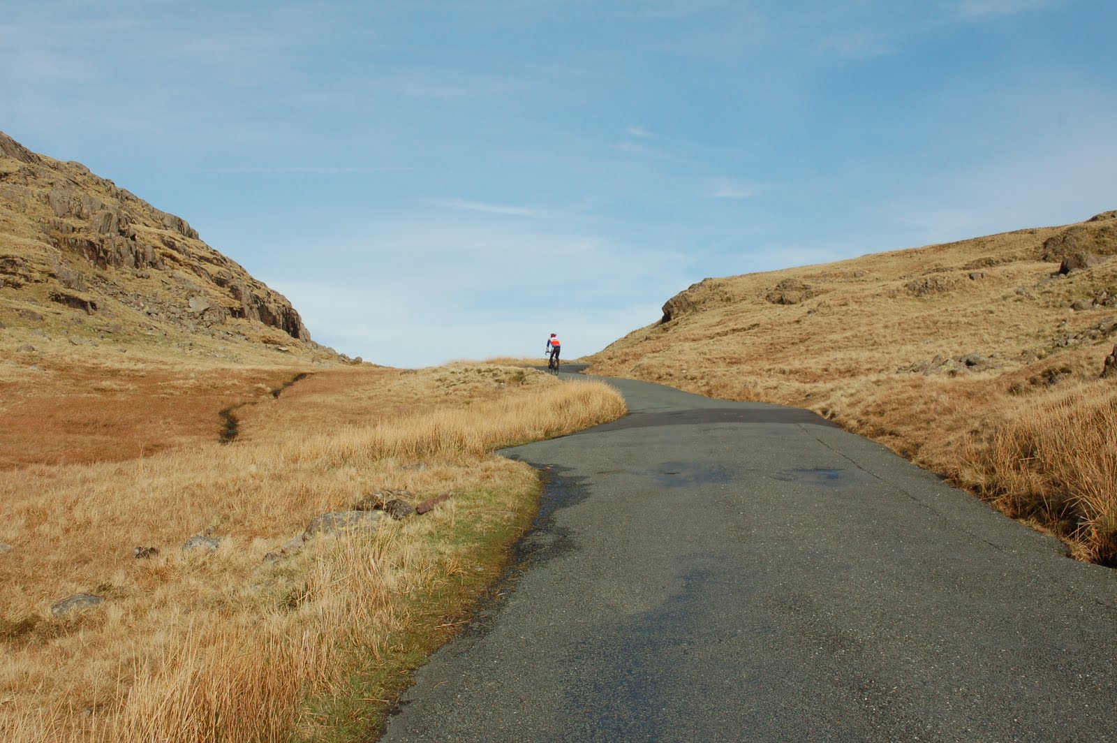
I was greeted at the top by my lovely lady who had driven all the way to the top - no mean feat believe me, and she still had the other side to drive down which is probably worse as the road is more twisting and the road surface is very poor. I has been likened to "riding down the side of a house" It really is a nerve shredding experience with your brakes on full throughout, your arms locked and your weight as far back as you dare.
Once down, all that remains is the short, spectacular ride up the Duddon Valley to the foot of Wrynose Pass.


With the descent of Wrynose complete all that remained was the final run into Coniston to the finish - about seven miles but it seems to take an eternity and I had nothing left to give. I almost rolled to the final check-in.

....and here is the final moment 111.7 miles, 8 hours 52 minutes and 7838 calories later, I dobbed my card in and The Fred Whitton Four Seasons was complete - a great, scenic but formidable and tough ride - highly recommended.

Here is a little video that I have created of the day - and don't forget to watch it in HD - just click the 240 or 360 in the bottom right corner of the player and change to 720.
Next stop, the Dragon Ride......
Subscribe to:
Posts (Atom)